班公錯檢視原始碼討論檢視歷史
 |
班公錯(拉達克語:Pangong Tso),藏語名哥木克哥那喇令錯,或錯木昂拉仁波(藏語:མཚོ་མོ་ངང་ལྷ་རིང་པོ།,威利:mtsho mo ngang lha ring po,THL:Tsomo Nganglha Ringpo)。
名稱由來
班公錯來自印度的拉達克語,意思是「高草原湖」[1]。錯木昂拉仁波是藏語,各資料有相異但類似的解釋--明媚而狹長的湖[2]、長脖天鵝湖[3]、長頸仙鶴湖[4]。 歷史上,該湖被視為五個由河道鏈接的小湖泊,班公錯這個名字只指最西邊一半在印度的其五之一。 從西向東這些湖泊的名稱分別為:[5][6][7]Pangong Tso(班公錯)、Tso Nyak、Rum Tso雙湖(胡惟德譯:襍爾木湖[7])、Nyak Tso(胡惟德譯:諾和湖[7])。整個湖群被藏語稱為錯木昂拉仁波。
自然地理
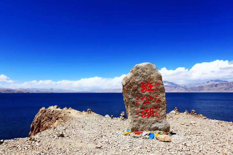
班公錯是青藏高原西部的一座湖泊,位於西藏和克什米爾邊境,中國和印度對該湖歸屬有爭議,現中國控制該湖東部約三分之二,印度控制西部約三分之一。 班公錯屬構造性湖泊,東西狹長,約延伸143公里,南北最寬處5公里,總面積604平方公里。該湖湖面平均海拔4241米,屬內流湖,流域面積28714平方公里。由三個狹長形小湖組成,其間有溝通水道。湖最深處約57米。湖水清澈,透明度3至4米。每年結冰期6個月。該湖東部水質為淡水,中西部為鹹水。
自然生態
 原圖鏈結 圖片來自linnietraveler.com |
班公錯又稱彭公湖,該湖泊位在獅泉河到多瑪的途中,藏語稱哥木克哥那喇令錯,意為「明媚而狹長的湖」。 湖中的鳥島有成千上萬的鷗鳥在此棲息,鷗鳥雁鴨歡舞飛翔、遮天蔽日成為阿里高原的一大奇觀,湖畔的牧人傳說湖中還有神龍、湖怪出沒,更增添了班公湖的神秘色彩。 湖中盛產特有的西藏裂腹魚和各種禽鳥,有鳥島數個,鳥蛋甚多。湖區植物種類近300種。岸邊紅柳簇擁,風景優美。
參考文獻
- ↑ Pangong Lake. 拉達克政府. 2019-10-29 [9 January 2020].
Pangong Lake, one of the most famous lakes in Leh Ladakh, derives its name from the Tibetan word, 「Pangong Tso」, which means 「high grassland lake」.
- ↑ 黃子燕. 中外旅遊休閒自然地理. 崧燁文化事業有限公司. 1 May 2018: 136. ISBN 978-957-563-112-3.
位於中國和喀什米爾邊境的班公錯,藏語意為「明媚而狹長的湖」
- ↑ 行走的尼爾. 西藏有處奇特聖湖,一面屬中國乾淨碧綠,一面屬印度連魚也不生長. 新浪網. 2019年10月05日 [19 January 2020].
藏語的名字是「措木昂拉仁波錯」,它的意思是「長脖子天鵝」
- ↑ 安才旦. 西藏旅遊. 五洲傳播出版社. 2002: 24. ISBN 978-7-80113-915-3.
藏語稱其為「措木昂拉仁波錯」 ,意為「長頸仙鶴湖」。
- ↑ 斯文·赫定. Scientific Results of a Journey in Central Asia 1899-1902: Central and West Tibet. Lithographic institute of the General staff of the Swedish army. 1907: 521.
From Noh to Bal Rawling followed the same route that I did along the northern shore of the Tso-ngombo, which he calls the Tso Mo Gualari, dividing it into the sections ›Tso Nyak, the twin lakes Rum Tso and Nyak Tso.› He says that it consists of a string of five lakes 120 m. in length, the four most southern of which are fresh, and Pangong, the most northerly, salt. They are joined together by channels about 60 feet in width and 15 feet deep, the current running at nearly 1½ mile an hour.
- ↑ Routes in Asia: Routes in the territories of the Maharaja of Jummoo and Kashmir, and adjacent countries. Office of the Superintendent of Government Printing. 1878: 31–33.
Only the lower lake (the Pangong Tso proper) lies in Ladak, the middle (Tso Nyak) and upper lakes being in Rudok territory. ... The waters of the western end are much more salt than those of the eastern end near Ot. in the stream connecting the Pangong Tso with Nyak Tso the water becomes drinkable, and rich grass is found on the banks.
- ↑ 7.0 7.1 7.2 胡惟德. 西藏全圖. 國會圖書館 (美國). 1904 [2020-01-19].